- U.S. Conditions
- Home
- Placerville California Weather

- Mobile Live Weather Conditions
- Mobile Placerville Forecast
- NOAA LIVE Weather Radio
- Air Quality Report
- Watering Index
- Irrigation Index
- Burn Index
- Current Area Weather Alerts
- LIVE I
- LIVE II
- Live III
- Live Weather Gauges
- LIVE WebCam
- Lightning Radar
- Miscellaneous
- Moon & Stars
- CoCoRaHS Precipation Map
- 2016 Solar Risings/Settings
- Daily Placerville Temp Summary
- Historic Daily Wx Extremes
- Historic Daily Temp Extremes
- Historic Rain/Temp Details
- Current Weather Trends
- Weather Station History
- Historic Weather Data
- Normals, Averages & Records
- 2 to 7 Day Wx Statistics
- Mesowest Current Conditions
- Monthly & Yearly Records
- Daily Weather Details
- Daily Rainfall Calendar
- Historic Rainfall
- Current Weather Graphs
- California Average Rainfall
- Current U.S. Weather & Info
- United States
- Current U.S. Weather Conditions
- North America Conditions
- Alaska Current Conditions
- Hawaii Current Conditions
- U.S. Weather Roundup w/temps
- Annual USA Rainfall
- Yesterday U.S. Temps
- U.S. Weather Advisory Map
- U.S. City Radiation Measurements
- Official U.S. Time & Zones
- Alaska
- Warnings-Watches-Advisories
- Annual Rainfall
- Live Meso Map Weather
- United States Weather
- Southwestern Weather Network
- Alaska Wx Conditions
- Mid-Atlantic Wx Conditions
- Mid-South Wx Conditions
- Midwest Wx Conditions
- Northeast Wx Conditions
- Northwest Wx Conditions
- The Plains Wx Conditions
- Rocky Mountain Wx Conditions
- Southeast Wx Conditions
- Southwest Wx Conditions
- Canada Weather
- Atlantic Region Wx Conditions
- Ontario Region Wx Conditions
- Quebec Region Wx Conditions
- Saskatchewan Region Wx Conditions
- Western Region Wx Conditions
- United Kingdom Weather
- United Kingdom Wx Conditions
- Europe Weather
- Europe Wx Conditions
- Austria Wx Conditions
- Benelux Wx Conditions
- Germany Wx Conditions
- Greece/Hellas Wx Conditions
- Iberian Peninsula Wx Conditions
- Scotland Wx Conditions
- Slovakia Wx Conditions
- Slovenia Wx Conditions
- Oceania Weather
- Australia Wx Conditions
- New Zealand Wx Conditions
- World Weather
- Global Affiliated Wx Network
- U.S. Climate Central
- U.S. Severe Wx & Fire Maps
- U.S. Lightning Center
- Earthquake-Volcano-Monsoon
- Snow Depths & Rainfall Totals
- U.S. 3 Day Precip Type Forecast
- U.S. Snow Depths
- U.S. Observed Precipitation
- National Snow Accumulation
- Northern Hemisphere snow
- Snow Probabilities & Percentile
- U.S. Snow Analyses Maps
- U.S. First Freeze Dates
- U.S. First Snow Dates
- California Rainfall Totals
- California Hydrologic Resources
- Donner Snowfall
- Historic Global Climate Maps
- U.S. Cities Current Air Quality
- U.S. Flight Rules
- U.S. Forecast
- Maps & Radar
- Smoke
- Radar
- U.S. Interactive Radar Map
- U.S. Regional Radar Maps 2
- U.S. Regional Radar Maps
- U.S. Fullpage Radar Map
- Canada Radar Map
- U.S. Fire Map
- U.S. Observations Map
- Tropical Storms Map
- Alaska Radar Map
- Northeast U.S. Radar Map
- Southeast U.S. Radar Map
- U.S. East Coast Radar Map
- N. Rockies Radar Map
- S. Mississippi Radar Map
- Central Great Lakes
- Pacific NW Radar Map
- Pacific SW Radar Map
- Southern Plains Radar Map
- S. Rockies Radar Map
- Upper Mississippi Valley
- Hawaii Radar Map
- Puerto Rico Radar Map
- U.S. City Radar with controls
- U.S. City Radar with out controls
- Large US Radar
- XLarge U.S. Radar
- World Lightning Radar
- Western U.S. Weather Maps
- Eastern U.S. Weather Maps
- NorCal Inland Radar
- NorCal Coastal Radar
- NorCal Northwest Coast
- Central CA. Radar
- Southern CA. Radar
- Satellite Imagery
- Satellite Directory Listings
- United States Satellite
- U.S. Color Infrared
- U.S. Color Infrared XLarge
- U.S. Visible
- U.S. Infrared
- U.S. Water Vapor
- U.S. Satellite w/Radar
- N America Rainfall Forecast
- N America Rainfall Forecast
- North America IR Satellite
- U.S. Multi Satellite Viewer
- U.S. Interactive Infrared Sat
- Xlarge U.S. Infrared (B/W) Satellite
- Xlarge U.S. Visible Satellite
- Xlarge U.S. Water Vapor Satellite
- Western U.S. & East Pacific
- Western U.S. Color Topo
- Northeast Pacific Topo WV
- N.E. Pacific Color IR
- Entire N. Pacific Sat Color IR
- Western U.S. VIS
- Western U.S. IR
- Western U.S. WV
- Western U.S. AVN
- Western U.S. Rainbow
- Western U.S. RGB
- Northeast Pacific VIS
- Northeast Pacific WV
- Northeast Pacific AVN
- Northeast Pacific Rainbow
- Northeast Pacific RGB
- Northeast Pacific X-Large IR
- Northeast Pacific X-Large VIS
- World Sea Temperatures
- Eastern U.S. & West Atlantic
- Western Atlantic Color Topo IR
- Western Atlantic Color WV
- Western Atlantic Color IR
- Eastern U.S. VIS
- Eastern U.S. IR
- Eastern U.S. WV
- North Atlantic VIS
- North Atlantic IR
- North Atlantic WV
- Western Atlantic Topo IR
- Western Atlantic Color WV
- Western Atlantic Color IR
- Western Atlantic X-large VIS
- Western Atlantic X-large IR
- U.S. - Atlantic - Pacific
- Hemispheric Half Disk Satellite
- GOES-WEST - U.S. & Pac IR2
- GOES-WEST - U.S. & Pac IR4
- GOES-WEST - U.S. & Pac VIS
- GOES-WEST - U.S. & Pac WV
- GOES-EAST - W. Atl & U.S. WV
- GOES16 - Americas GeoColor
- GOES16 - Americas Infrared4
- GOES16 - Americas Visible
- GOES16 - Americas WV
- MET-PRIME - UK & Europe IR
- MET-PRIME - UK & Europe VIS
- MET-PRIME - UK & Europe WV
- COMS - W Pac & Japan IR
- COMS - W Pac & Japan Vis
- COMS - W Pac & Japan WV
- HIMAWARI - W Pac-Guam IR
- HIMAWARI - W Pac-Guam VIS
- HIMAWARI - W Pac-Guam WV
- HIMAWARI - W Pac-Guam RGB
-
Hemispheric Full Disk Satellite
- GOES-EAST 16 GeoColor
- GOES-EAST 16 Longwave IR
- GOES-EAST 16 WV IR
- GOES-WEST 17 GeoColor
- GOES-WEST 17 Longwave IR
- GOES-WEST 17 WV IR
- GOES-WEST 5-Day IR Sat
- GOES-WEST 5-Day VIS Sat
- GOES-WEST 5-Day WV Sat
- MET-PRIME - Eur. & Africa IR
- MET-PRIME - Eur. & Africa VIS
- MET-PRIME - Eur. & Africa WV
- HIMAWARI - W Pac to Aus IR
- HIMAWARI - W Pac to Aus VIS
- HIMAWARI - W Pac to Aus WV
- HIMAWARI - W Pac & Aus RGB
- COMS-1 - W Pac to Aus IR
- COMS-1 - W Pac to Aus VIS
- COMS-1 - W Pac to Aus WV
- FY2G - Ind Ocean & China IR
- FY2G - Ind Ocean & China VIS
- FY2G - Ind Ocean & China WV
- MET-IODC - Africa-Mideast IR
- MET-IODC - Africa-Mideast VIS
- MET-IODC - Africa-Mideast WV
-
Extra Wide View Satellite
- Western Atlantic & Pacific
- West Atlantic Color Topo IR
- West Atlantic Color Sat IR
- West Atlantic Satellite IR
- W Atlantic Sat Color Topo WV
- West Pacific Color Topo IR
- West Pacific Color Sat IR
- West Pacific Satellite IR
- West Pac Sat Color Topo WV
- S Pacific Color Topo IR
- SSW Pacific Ocean Color IR
- SSW Pacific Satellite IR
- S Pac Sat Color Topo WV
- S. Pacific Sat Color Topo IR 2
- S. Pacific Sat Color IR 2
- S. Pacific Sat WV 2
- N. Pacific GeoColor Satellite
- N. Pacific WV Satellite
- UK & Europe Satellite
- Indian Ocean Satellite
- Africa Satellite
- Global Satellite
- Canada Satellite
- Arctic & Antarctic IR Sat
- Alaska Satellite
- Hawaii Satellite
- U.S. Fire Monitoring Satellite
- Smoke
- Models
- Surface Analysis Dirctory
- North America Models
- HRRR Hourly - U.S. High Res
- HRRR-SubHourly - High Res
- RAP - (Rapid Refresh) Listings
- RUC - (Rapid Update) Listings
- HREF - Listings
- HREF U.S. Southwest Listings
- SREF Listings
- GFS Listings
- GEFS Ensemble Listings
- GEFS Spaghetti Listings
- GFS Alaska Listings
- NAM Listings
- NAEFS Listings
- U.S. Color Surface Map
- U.S. Surface Map
- Current U.S. Mesoscale Alerts
- U.S. SPC Mesoscale Analysis
- Western U.S. Surface Map
- Midwest Surface Map
- Southeast U.S. Surface Map
- Canada Surface Map
- Gulf-Mexico-Caribbean Sur Map
- U.S. GFS-LAMP Analysis
- Eastern & Western U.S.
- Alaska Models
- Polar Models
- Arctic Models
- Europe Models
- North Pacific Models
- East Pacific Models
- Atlantic Models
- Western North Atlantic Models
- Caribbean Models
- Atlantic & Pacific Models
- South Pacific Models
- Africa Models
- Asia Models
- India & Pakistan
- Australia
- South America
- N. America - U.S. Surface Maps
- U.S. HPA Layer Models
- NE. Pacific 700-850-HPA Layer
- NE. Pacific 500-850-HPA Layer
- NE. Pacific 400-850-HPA Layer
- NE. Pacific 300-850-HPA Layer
- NE. Pacific 250-850-HPA Layer
- NE. Pacific 200-700-HPA Layer
- W. Atlantic 700-850-HPA Layer
- W. Atlantic 500-850-HPA Layer
- W. Atlantic 400-850-HPA Layer
- W. Atlantic 300-850-HPA Layer
- W. Atlantic 250-850-HPA Layer
- W. Atlantic 200-700-HPA Layer
- U.S. Converge & Diverge
- U.S. Wind Shear & Vorticity
- North Polar Ice Drift
- Canada
- Radar & Satellite
- Radar
- Canada Radar
- Pacific Province Radar
- Prairies Province Radar
- Ontario Province Radar
- Quebec Province Radar
- Atlantic Province Radar
- Canada Regional Radar
- Canada Radar Status
- Canada Aviation Webcams
- N. America Lightning Strikes
- National Satellite
- Canada GeoColor IR Satellite
- Canada Infrared Sat Loop
- Canada Xlarge IR Sat Photo
- Canada Infrared Sat Photo 1
- Canada Infrared Sat Photo 2
- Canada Visable Sat Photo
- Canada Composit w/ Arctic
- Regional Satellite
- West Canada Xlarge IR Sat
- East Canada Xlarge IR Sat
- Canada Fire
- Current Conditions
- Canada Statements & Alerts
- Marine Warnings & Forecast
- Canada Sea Ice Charts
- Canada Climate Directory 1
- Canada Climate Directory 2
- Canada Average Rainfall
- Recent Canada Earthquakes
- Radar & Satellite
- World Wx
- World Weather Information
- World Lightning Radar
- Global Lightning Radar
- North America Lightning Radar
- Europe Lightning Radar
- Central Europe Lightning Radar
- Southeast Europe Lightning Radar
- UK Lightning Radar
- Africa/Mideast Lightning Radar
- South Africa Lightning Radar
- Australia & N.Z. Lightning Radar
- New Zealand Lightning Radar
- Asia Lightning Radar
- South America Lightning Radar
- S.W. Pacific U.S. Lightning Radar
- Global Total Precipitable Water
- World Climate Directory
- World Temperature Extremes
- World Drought Map
- World Wind Direction Animation
- World High Temperatures Map
- World Low Temperatures Map
- World Sea Surface Temps
- World Realtime Maps
- World Annual Temperatures Map
- World Satellite Directory
- Entire World IR Satellite
- XLarge World IR Satellite
- Western Hemisphere Sat
- Antarctica Composite Sat IR
- Antarctica Satellite Photo
- World Lightning Radar
- World Current Conditions
- World Current Conditions
- N. America Current Conditons
- U.S. Current Conditons
- Alaska Current Conditons
- Hawaii Current Conditons
- Africa Current Conditons
- Australia Current Conditons
- Canada Current Conditons
- Caribbean Current Conditons
- Central America Conditons
- Eastern Europe Current Conditons
- Middleeast Current Conditons
- Mexico Current Conditons
- New Zealand Conditons
- North Asia Current Conditons
- South America Current Conditons
- South Asia Current Conditons
- UK Current Conditons
- W. Europe Current Conditons
- Europe Infrared Satellite
- Europe Infrared Satellite
- Alps Infrared Satellite
- Balkans Infrared Satellite
- Baltic Infrared Satellite
- France Infrared Satellite
- Germany Infrared Satellite
- Greece Infrared Satellite
- Hungary Infrared Satellite
- Italy Infrared Satellite
- Netherlands Infrared Satellite
- Poland Infrared Satellite
- Russa Infrared Satellite
- Scandinavia Infrared Satellite
- Southeast Europe IR Satellite
- Spain Infrared Satellite
- Turkey Infrared Satellite
- UK Infrared Satellite
- Africa Infrared Satellite
- Africa Infrared Satellite
- Algeria Infrared Satellite
- Canary Islands IR Satellite
- Cameroon Infrared Satellite
- Central Africa Infrared Satellite
- Chad Infrared Satellite
- Congo Infrared Satellite
- Egypt Infrared Satellite
- Ethiopia Infrared Satellite
- Israel Infrared Satellite
- Libya Infrared Satellite
- Madagascar Infrared Satellite
- Morocco Infrared Satellite
- Namibia Infrared Satellite
- Saudi Arabia IR Satellite
- Somalia Infrared Satellite
- South Africa IR Satellite
- Sudan Infrared Satellite
- Tanzania Infrared Satellite
- Tunisia Infrared Satellite
- West Africa IR Satellite
- Zambia Infrared Satellite
- Europe Animated Radar
- Europe Animated Radar
- Alps Animated Radar
- Balkans Animated Radar
- Baltic Animated Radar
- France Animated Radar
- Germany Animated Radar
- Greece Animated Radar
- Hungary Animated Radar
- Netherlands Animated Radar
- Poland Animated Radar
- Russia Animated Radar
- Scandinavia Animated Radar
- Southeast Europe Radar
- Turkey Animated Radar
- Africa Animated Radar
- Africa Animated Radar
- Algeria Animated Radar
- Australia & N. Zealand Radar
- Cameroon Animated Radar
- Canary Islands Radar
- Central Africa Radar
- Chad Animated Radar
- Congo Animated Radar
- Egypt Animated Radar
- Ethiopia Animated Radar
- Israel Animated Radar
- Libya Animated Radar
- Madagascar Animated Radar
- Morocco Animated Radar
- Namibia Animated Radar
- Saudi Arabia Animated Radar
- Somalia Animated Radar
- South Africa Animated Radar
- Sudan Animated Radar
- Tanzania Animated Radar
- Tunisia Animated Radar
- West Africa Animated Radar
- Zambia Animated Radar
- Africa
- Africa/Mideast Lightning Radar
- Africa Current Conditions
- Africa Infrared Satellite
- Africa Visible Satellite
- Africa Animated Radar
- Eastern Hem Full Disk IR Sat
- Eastern Hem Full Disk VIS Sat
- Eastern Hem Full Disk WV Sat
- NW Indian Ocean Color IR
- NW Indian Ocean Sat Color IR
- NW Indian Ocean Sat IR
- NW Indian Ocean Color WV
- South Africa
- Asia - Northern & Central
- Asia - Eastern & Southeastern
- Asia - Southern & Southwest
- Europe - British Isles
- Live UK Weather Alerts
- Current Weather Conditions
- British Iles IR Satellite
- British Iles VIS Satellite
- British Isles Radar
- Satellite Imagery
- Europe Infrared Satellite
- Europe Visible Satellite
- British Isles Infrared Satellite
- British Isles Visible Satellite
- British Isles IR Closeup Sat
- UK & European Half Disk Sat VIS
- UK & European Half Disk Sat IR
- UK & Europe Half Disk Sat WV
- Europe 12hr Satellite Loop
- Europe 24hr Satellite Loop
- Spain & Portugal IR Satellite
- Europe IR Color Topo Satellite
- Average Rainfall
- British Isles Rainfall Forecast
- UK Cities Live Conditions
- Live Current Conditions Map1
- UK Live Weather Map
- Scotland Live Weather Map
- UK & Ireland Lightning Radar
- British Isles Buoy's
- Recent UK Earthquakes
- 24-168 Hr Temp Forecast
- Total Precipitable Water
- Anomoly Precipitable Water
- Europe - Western
- Europe - Eastern
- Europe Current Conditions
- Europe Animated Radar
- Europe Severe Weather Map
- Eastern Europe IR Satellite
- Eastern Europe VIS Satellite
- UK & European Half Disk Sat VIS
- UK & European Half Disk Sat IR
- UK & Europe Half Disk Sat WV
- Europe 12hr Satellite Loop
- Europe 24hr Satellite Loop
- Europe Live Lightning Radar
- Poland Live Weather Map
- Slovakia Live Weather Map
- Slovenia Live Weather Map
- Israel
- Caribbean
- Greenland
- Mexico
- Middle East
- Oceania - Australia
- Oceania - New Zealand
- North America
- South America
- Central America
- World Weather Information
- Tropical
- More
- Historic Global Maps
- Weather Documents
- Natural Science
- Placerville CA Wx Records
- Placerville Mobile Live
- Live Weather Gauges
- Moon & Stars
- CoCoRaHS Precipation Map
- 2016 Solar Risings/Settings
- Daily Placerville Temp Summary
- Historic Daily Wx Extremes
- Historic Daily Temp Extremes
- Historic Rain/Temp Details
- Current Weather Trends
- Weather Station History
- Historic Weather Data
- Normals, Averages & Records
- 2 to 7 Day Wx Statistics
- Mesowest Current Conditions
- Monthly & Yearly Records
- Daily Weather Details
- Daily Rainfall Calendar
- Historic Rainfall
- Current Weather Graphs
- California Average Rainfall
- Miscellaneous
- Mobile Live Weather Conditions
- Mobile Placerville Forecast
- NOAA LIVE Weather Radio
- Air Quality Report
- Watering Index
- Irrigation Index
- Burn Index
- Current Area Weather Alerts
- LIVE I
- LIVE II
- Live III
- Live Weather Gauges
- LIVE WebCam
- Lightning Radar
- El Dorado County Burn Days
- Latest El Nino / La Nina Maps
- Space Station Live ISS Feed
- Conversion Calculators & Tools
- Sitemap
- About Us!
- Historic Global Maps
When temperature's or rainfall amounts are first posted to the map the data is typically about 6 to 10 minutes older than real time. Since the map refreshes about every 10 minutes, the rainfall and temperature data can be up to 10 minutes old when first posted on the map. For the occasional unresponsive weather station the data can be older. When NOT in "Clear Air Mode" and precipitation is present, the map will refreshe much faster, about every 2 minutes.
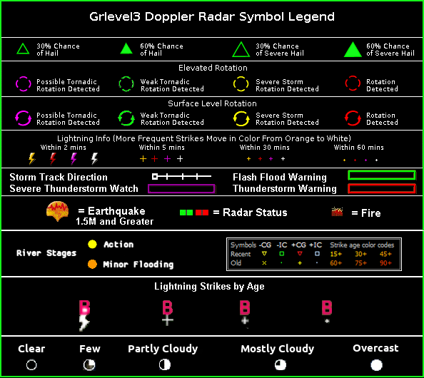
Time Stamps - Radar time stamps are in "Greenwich Mean Time" (AKA: GMT/UTC/Z). Directly below the time display, which is located in the lower right hand corner on the images, you will find the current "Greenwich Mean Time". Pacific time is 8 hours behind during our "Standard Time" and 7 hours behind during our "Daylight Savings Time".
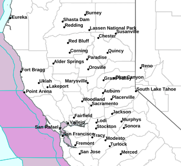
Display Policy - We always try to turn off all excess clutter during active radar times, except for the city names and temperatures or precipitation amounts. The city names stay so viewers can more easily find their approximate locations. The city names text should be centered right on top of the true location on the map, or at the least very, very close.
When there is no reasonable threat of rainfall/showers we activate the current temperatures or current rainfall amounts, earthquake icons, fire icons, highway numbers, radar site activity status bars and radar site names.
Clear Air Mode - NOAA's U.S. radar stations operate in either 'Clear Air Mode' when there is no precipitation in the area or 'Precipitation Mode' when rain is in the area. Radar is at its most sensitive state of operation when in clear air mode. The antenna rotates at its slowest rate permitting the radar to sample a given volume of the atmosphere longer giving it the ability to detect smaller objects than when in precipitation mode. Much of what you see in clear air mode is airborne dust & particulate matter.
Precipitation Mode - Radar doesn't need to be as sensitive as in clear air mode. This is because rainfall provides plenty of returning signals giving you a much cleaner view of any rainfall in the area without all of the clutter seen in clear air mode.
Storm Tracks - The Storm Track Feature, when in use, allows you to see what direction or track the storm is currently headed to. This feature shows a white line extending out of a little white square box from the center of a storm cell. The "x"'s along this white line indicate every 15 minutes where the center of the storm is forecast to be, based on its current speed and direction. For an example, the 4th "x" shows where the storm will be in an hour given its current tracking. The longer the white line the faster the storm is moving.
Using Zoom - You can easily zoom in by clicking on the "Zoom Button" and then left clicking on the map. With every click the map will zoom in more. Once zoomed in you can then "Click and Drag" the map. The "Click and Drag" is only available when zoomed in. This feature allows you to zoom right into your own neighborhood. To reset the map to the original viewing level, simply click on the "Unzoom Button".
Note - Typically you will see area temperatures or precipitation amounts, fires, current earthquakes, and highway markers when there is no precipitation in the area. When there is rainfall occuring in the area the map is usually cleared to only show the radar, city names and temperatures or precipitation along with rain related icons like hail and cloud rotation on the map IF enabled. This is because we don't want to put up anything extra that will obstruct from the view of the radar during any precipitation event.