WW 252 TORNADO AL MS CW 170350Z - 170800Z

URGENT - IMMEDIATE BROADCAST REQUESTED
Tornado Watch Number 252
NWS Storm Prediction Center Norman OK
1050 PM CDT Thu May 16 2024

The NWS Storm Prediction Center has issued a

* Tornado Watch for portions of
  Southern Alabama
  Southern Mississippi
  Coastal Waters

* Effective this Thursday night and Friday morning from 1050 PM
  until 300 AM CDT.

* Primary threats include...
  A couple tornadoes possible
  Isolated damaging wind gusts to 70 mph possible

SUMMARY...A severe squall line over southeast Louisiana will
continue east and move into the Watch area tonight.  In addition to
the risk for a couple of tornadoes, severe gusts (60-70 mph) capable
of wind damage may accompany the more intense thunderstorm cores and
outflow surges in the squall line.

The tornado watch area is approximately along and 30 statute miles
north and south of a line from 35 miles west of Gulfport MS to 30
miles southeast of Mobile AL. For a complete depiction of the watch
see the associated watch outline update (WOUS64 KWNS WOU2).

PRECAUTIONARY/PREPAREDNESS ACTIONS...

REMEMBER...A Tornado Watch means conditions are favorable for
tornadoes and severe thunderstorms in and close to the watch
area. Persons in these areas should be on the lookout for
threatening weather conditions and listen for later statements
and possible warnings.

&&

OTHER WATCH INFORMATION...CONTINUE...WW 250...WW 251...

AVIATION...Tornadoes and a few severe thunderstorms with hail
surface and aloft to 1.5 inches. Extreme turbulence and surface wind
gusts to 60 knots. A few cumulonimbi with maximum tops to 500. Mean
storm motion vector 27035.

...Smith
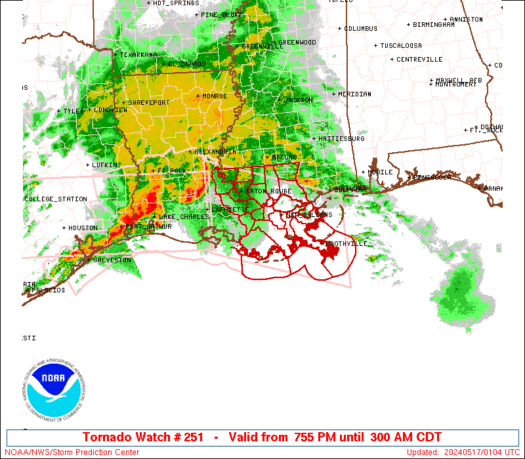
WW 251 TORNADO LA CW 170055Z - 170800Z
URGENT - IMMEDIATE BROADCAST REQUESTED
Tornado Watch Number 251
NWS Storm Prediction Center Norman OK
755 PM CDT Thu May 16 2024

The NWS Storm Prediction Center has issued a

* Tornado Watch for portions of
  Southeast Louisiana
  Coastal Waters

* Effective this Thursday night and Friday morning from 755 PM
  until 300 AM CDT.

* Primary threats include...
  A couple tornadoes possible
  Scattered damaging winds and isolated significant gusts to 75
    mph possible
  Isolated large hail events to 1.5 inches in diameter possible

SUMMARY...A broken squall line will move east into southeast
Louisiana this evening and progress east across the Watch area
tonight.  In addition to the risk for a couple of tornadoes, severe
gusts (60-75 mph) capable of wind damage may accompany the more
intense portions of the squall line.

The tornado watch area is approximately along and 65 statute miles
north and south of a line from 5 miles north of Lafayette LA to 35
miles east of Boothville LA. For a complete depiction of the watch
see the associated watch outline update (WOUS64 KWNS WOU1).

PRECAUTIONARY/PREPAREDNESS ACTIONS...

REMEMBER...A Tornado Watch means conditions are favorable for
tornadoes and severe thunderstorms in and close to the watch
area. Persons in these areas should be on the lookout for
threatening weather conditions and listen for later statements
and possible warnings.

&&

OTHER WATCH INFORMATION...CONTINUE...WW 249...WW 250...

AVIATION...Tornadoes and a few severe thunderstorms with hail
surface and aloft to 1.5 inches. Extreme turbulence and surface wind
gusts to 65 knots. A few cumulonimbi with maximum tops to 500. Mean
storm motion vector 27035.

...Smith
WW 0252 Status Updates
STATUS FOR WATCH 0252 HAS NOT BEEN ISSUED YET
WW 0251 Status Updates
STATUS REPORT ON WW 251

SEVERE WEATHER THREAT CONTINUES RIGHT OF A LINE FROM 10 ENE 7R4
TO 30 W MSY TO 30 S MCB.

..SPC..05/17/24

ATTN...WFO...LIX...


STATUS REPORT FOR WT 251

SEVERE WEATHER THREAT CONTINUES FOR THE FOLLOWING AREAS

LAC007-051-057-071-075-087-089-093-095-103-105-109-117-170540-

LA
.    LOUISIANA PARISHES INCLUDED ARE

ASSUMPTION           JEFFERSON           LAFOURCHE
ORLEANS              PLAQUEMINES         ST. BERNARD
ST. CHARLES          ST. JAMES           ST. JOHN THE BAPTIST
ST. TAMMANY          TANGIPAHOA          TERREBONNE
WASHINGTON


GMZ530-534-538-550-552-555-170540-

CW

.    ADJACENT COASTAL WATERS INCLUDED ARE

LAKE PONTCHARTRAIN AND LAKE MAUREPAS

LAKE BORGNE

BRETON SOUND

COASTAL WATERS FROM PORT FOURCHON LA TO LOWER ATCHAFALAYA RIVER
WW 0250 Status Updates
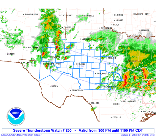
STATUS REPORT ON WW 250

SEVERE WEATHER THREAT CONTINUES RIGHT OF A LINE FROM 55 SSW SJT
TO 20 SSE SJT TO 15 S BWD.

..BENTLEY..05/17/24

ATTN...WFO...MAF...SJT...LUB...


STATUS REPORT FOR WS 250

SEVERE WEATHER THREAT CONTINUES FOR THE FOLLOWING AREAS

TXC095-267-307-319-327-411-413-435-170440-

TX
.    TEXAS COUNTIES INCLUDED ARE

CONCHO               KIMBLE              MCCULLOCH
MASON                MENARD              SAN SABA
SCHLEICHER           SUTTON


THE WATCH STATUS MESSAGE IS FOR GUIDANCE PURPOSES ONLY.  PLEASE
REFER TO WATCH COUNTY NOTIFICATION STATEMENTS FOR OFFICIAL
INFORMATION ON COUNTIES...INDEPENDENT CITIES AND MARINE ZONES
CLEARED FROM SEVERE THUNDERSTORM AND TORNADO WATCHES.
WW 0249 Status Updates
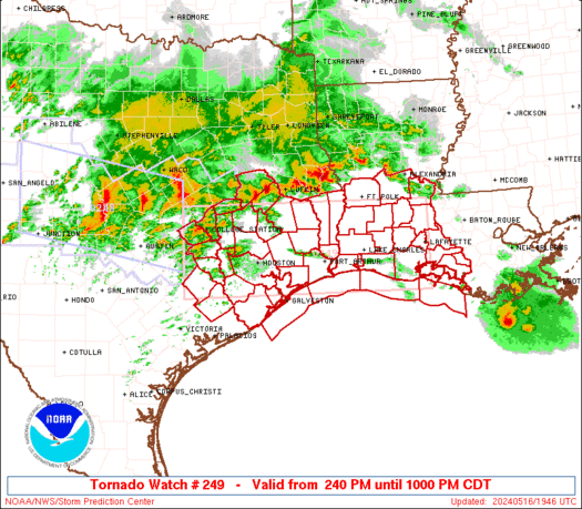
STATUS REPORT ON WW 249

SEVERE WEATHER THREAT CONTINUES RIGHT OF A LINE FROM 5 NE GLS TO
20 NE LCH TO 15 ESE POE.

..SPC..05/17/24

ATTN...WFO...LCH...HGX...


STATUS REPORT FOR WT 249

SEVERE WEATHER THREAT CONTINUES FOR THE FOLLOWING AREAS

LAC001-003-019-023-039-045-053-055-097-099-101-113-170240-

LA
.    LOUISIANA PARISHES INCLUDED ARE

ACADIA               ALLEN               CALCASIEU
CAMERON              EVANGELINE          IBERIA
JEFFERSON DAVIS      LAFAYETTE           ST. LANDRY
ST. MARTIN           ST. MARY            VERMILION


TXC039-071-167-245-170240-

TX
.    TEXAS COUNTIES INCLUDED ARE

BRAZORIA             CHAMBERS            GALVESTON
JEFFERSON


GMZ335-355-430-432-435-436-450-452-455-170240-

CW

.    ADJACENT COASTAL WATERS INCLUDED ARE
No Mesoscale Discussions are in effect as of Fri May 17 05:16:08 UTC 2024.SPC 0100Z Day 1 Outlook

Day 1 Convective Outlook
NWS Storm Prediction Center Norman OK
0746 PM CDT Thu May 16 2024

Valid 170100Z - 171200Z

...THERE IS A SLIGHT RISK OF SEVERE THUNDERSTORMS THIS EVENING INTO
TONIGHT ACROSS PARTS OF THE TEXAS EDWARDS PLATEAU...THE UPPER TEXAS
COAST AND SOUTHERN LOUISIANA...

...SUMMARY...
An organized cluster of storms may pose a continuing risk for severe
wind gusts across parts of southern Louisiana through late evening.

...01Z Update...
A large, modestly organized cluster of storms is in the process of
propagating east-southeastward across upper Texas coastal areas and
southwestern Louisiana.  Ahead of this activity, inland of the
Louisiana coast, notable boundary-layer layer cooling has already
occurred (4-8+ degrees the past 3 hours), beneath relatively warm
layers evident in the lower/mid-troposphere in the 00Z soundings
(e.g. Lake Charles).  However, it is still possible that low-level
moistening off the Gulf of Mexico, coincident with strengthening
south to southwesterly flow (30-50+ kt) in the 850-700 layer, may
contribute to a continuing severe wind risk with the convective
cluster across at least southern portions of Louisiana through mid
to late evening.

In the wake of the prominent lead convective cluster, outflow has
contributed to substantial stabilization of the low-level
environment across much of central Texas toward upper/middle Texas
coastal areas and Deep South Texas.  Models suggest little
appreciable modification this evening, with further southward and
southwestward progression of the outflow boundary into Deep South
Texas and the Rio Grande Valley.  As strong to severe convection now
spreading across the Edwards Plateau vicinity encounters this
environment during the next few hours, it seems likely to weaken.

..Kerr.. 05/17/2024
|